Geolocate

Brandomil topographic map

Click on the map to display elevation.

About this map
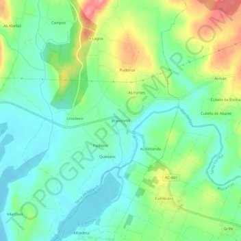
Name: Brandomil topographic map, elevation, terrain.

Location: Brandomil, Zas, Tierra de Soneira, La Coruña, Galicia, 15859, España (42.99067 -8.94534 43.03067 -8.90534)

Average elevation: 313 m

Minimum elevation: 281 m

Maximum elevation: 378 m

Other topographic maps

Click on a map to view its topography, its elevation and its terrain.

Vimianzo

España > Galicia > Tierra de Soneira

Average elevation: 222 m

Baio

España > Galicia > Tierra de Soneira > Zas

Average elevation: 198 m

Camelle

España > Galicia > Tierra de Soneira > Camariñas

Average elevation: 87 m

Calo

España > Galicia > Tierra de Soneira

Average elevation: 166 m

Bamiro

España > Galicia > Tierra de Soneira

Average elevation: 184 m

Zas

España > Galicia > Tierra de Soneira

Average elevation: 293 m

Brandoñas

España > Galicia > Tierra de Soneira > Zas

Average elevation: 296 m

Camariñas

España > Galicia > Tierra de Soneira

Coordenadas geográficas de Camariñas: Latitud: 43.1286, Longitud: -9.18493 - 43° 7′ 43″ Norte, 9° 11′ 6″ Oeste. Superficie de Camariñas: 5.160 hectáreas o 51,60 km². Altitud de Camariñas: 10 m.

Average elevation: 27 m

Gear up for your next adventure:

🧢Hiking Hat - Sun-protective and breathable hats for long treks
🔥Camping Stove - Portable stoves to cook outdoors with ease
⛺Family Camping Tent - Spacious tent suitable for family camping trips
🧦Outdoor Socks - Durable socks designed for hiking and outdoor sports
🥾Trail Hiking Shoes - Durable shoes designed for rugged trails

As an Amazon Associate, this site earns from qualifying purchases at no extra cost to you.