Geolocate

Koksar topographic map

Click on the map to display elevation.

About this map

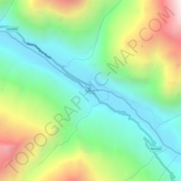
Name: Koksar topographic map, elevation, terrain.

Location: Koksar, Lahul, Lahaul and Spiti, Himachal Pradesh, India (32.39516 77.21389 32.43516 77.25389)

Average elevation: 3,634 m

Minimum elevation: 3,100 m

Maximum elevation: 4,677 m

Other topographic maps

Click on a map to view its topography, its elevation and its terrain.

Chandratal Lake

India > Himachal Pradesh > Lahul

Average elevation: 4,403 m

Suraj Tal

India > Himachal Pradesh > Lahul

Average elevation: 5,007 m

Chandratal Lake

India > Himachal Pradesh > Lahul

Average elevation: 4,403 m

Gear up for your next adventure:

🧤Insulated Winter Gloves - Heavy-duty protection for sub-zero Canadian adventures
🥾Hiking Gaiters - Protect legs and shoes from mud, snow, and debris
🧴First Aid Kit - Essential first aid supplies for outdoor emergencies
❄️Traction Ice Cleats - Slip-on spikes for icy trails and winter hiking
🥾Waterproof Hiking Shoes - Durable shoes for wet and rugged trails

As an Amazon Associate, this site earns from qualifying purchases at no extra cost to you.