
Make a donation
Gear up for your next adventure:
As an Amazon Associate, this site earns from qualifying purchases at no extra cost to you.
Neugreifenberg topographic map
Click on the map to display elevation.
Make a donation
Gear up for your next adventure:
As an Amazon Associate, this site earns from qualifying purchases at no extra cost to you.
About this map
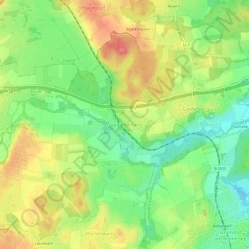
Name: Neugreifenberg topographic map, elevation, terrain.
Average elevation: 577 m
Minimum elevation: 541 m
Maximum elevation: 618 m
Make a donation
Gear up for your next adventure:
As an Amazon Associate, this site earns from qualifying purchases at no extra cost to you.
Other topographic maps
Click on a map to view its topography, its elevation and its terrain.
Schondorf am Ammersee
Deutschland > Bayern > Landkreis Landsberg am Lech
Schondorf liegt etwa 40 Kilometer westlich von München und etwa 40 Kilometer südöstlich von Augsburg am Westufer des Ammersees im Landkreis Landsberg am Lech. Der Höhenunterschied im Gemeindegebiet beträgt ungefähr 70 Meter. Die Gemeinde ist seit 16. Januar 1976 staatlich anerkannter Luftkurort.
Average elevation: 555 m