
West Clare Municipal District topographic map
Interactive map
Click on the map to display elevation.
About this map
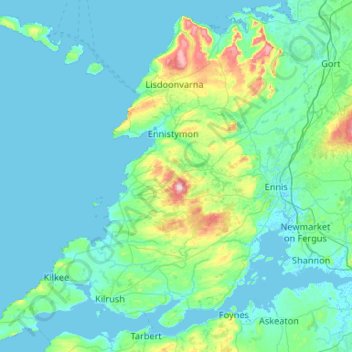
Name: West Clare Municipal District topographic map, elevation, terrain.
Location: West Clare Municipal District, County Clare, Munster, Ireland (52.55447 -9.93876 53.16891 -8.88244)
Average elevation: 37 m
Minimum elevation: -2 m
Maximum elevation: 386 m
Other topographic maps
Click on a map to view its topography, its elevation and its terrain.
Saint Catherines
Saint Catherines, Boherglass ED, Killaloe Municipal District, County Clare, Munster, Ireland
Average elevation: 91 m
Cliffs of Moher
Cliffs of Moher, Ballysteen ED, West Clare Municipal District, County Clare, Munster, Ireland
Average elevation: 55 m
Elmvale
Elmvale, Killinaboy ED, West Clare Municipal District, County Clare, Munster, Ireland
Average elevation: 53 m
Broadford
Broadford, Kilseily ED, Killaloe Municipal District, County Clare, Munster, Ireland
Average elevation: 95 m
Ardnacrusha
Ardnacrusha, Ballyglass ED, Shannon Municipal District, County Clare, Munster, V94 HXW5, Ireland
Average elevation: 39 m
Killaloe
Killaloe, Killaloe ED, Killaloe Municipal District, County Clare, Munster, Ireland
Average elevation: 58 m