
Make a donation
Gear up for your next adventure:
As an Amazon Associate, this site earns from qualifying purchases at no extra cost to you.
Diavolezza topographic map
Click on the map to display elevation.
Make a donation
Gear up for your next adventure:
As an Amazon Associate, this site earns from qualifying purchases at no extra cost to you.
Diavolezza
The Diavolezza is a col and ski resort above the Val Bernina in Graubünden. The col has an altitude of 2,958 metres (9,705 ft) and is located between Munt Pers (northwest, 3,207 metres (10,522 ft)) and Piz Trovat (southeast, 3,146 metres (10,322 ft)).
Make a donation
Gear up for your next adventure:
As an Amazon Associate, this site earns from qualifying purchases at no extra cost to you.
About this map
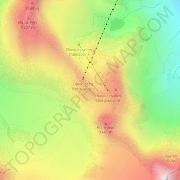
Name: Diavolezza topographic map, elevation, terrain.
Location: Diavolezza, Pontresina, Maloja, Grisons, 7504, Switzerland (46.41065 9.96701 46.41075 9.96711)
Average elevation: 2,781 m
Minimum elevation: 2,218 m
Maximum elevation: 3,357 m
Make a donation
Gear up for your next adventure:
As an Amazon Associate, this site earns from qualifying purchases at no extra cost to you.
Other topographic maps
Click on a map to view its topography, its elevation and its terrain.