Geolocate

Tambulilid topographic map

Click on the map to display elevation.

About this map
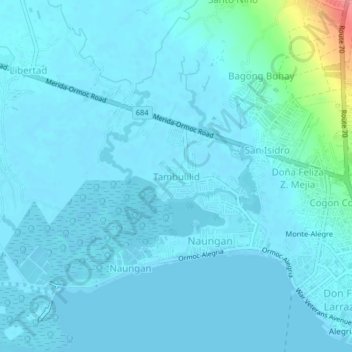
Name: Tambulilid topographic map, elevation, terrain.

Location: Tambulilid, Ormoc, Leyte, Eastern Visayas, 6541, Philippines (11.00316 124.56462 11.04316 124.60462)

Average elevation: 8 m

Minimum elevation: -2 m

Maximum elevation: 87 m

Other topographic maps

Click on a map to view its topography, its elevation and its terrain.
Binahaan River

Philippines > Leyte > Ormoc

Average elevation: 546 m

Binahaan River

Philippines > Leyte > Ormoc

Average elevation: 495 m

Ormoc City Proper

Philippines > Leyte > Ormoc

Average elevation: 18 m

Gear up for your next adventure:

🔋Emergency Crank Radio - Weather alerts and power without needing batteries
🔪Outdoor Multitool - Versatile tool for repairs and food prep in the wild
🥾Trekking Boots - Durable boots for long-distance trekking
💡Portable Camping Lamp - Rechargeable lamp for campsite lighting
🥾Trail Hiking Socks - Comfortable socks to prevent blisters and fatigue

As an Amazon Associate, this site earns from qualifying purchases at no extra cost to you.