
Make a donation
Gear up for your next adventure:
As an Amazon Associate, this site earns from qualifying purchases at no extra cost to you.
Hasbergen topographic map
Click on the map to display elevation.
Make a donation
Gear up for your next adventure:
As an Amazon Associate, this site earns from qualifying purchases at no extra cost to you.
Hasbergen
Der Ort liegt teilweise im Bereich des Hüggel, der zum Landschaftsschutzgebiet Teutoburger Wald gehört. Die Höhenlage reicht von 62 m bis 228 m über NN. In Hasbergen liegt der 108 Meter hohe Rote Berg. Am nördlichen Ortsrand bildet der Wilkenbach die Grenze zur Nachbarstadt Osnabrück.
Make a donation
Gear up for your next adventure:
As an Amazon Associate, this site earns from qualifying purchases at no extra cost to you.
About this map
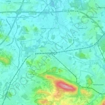
Name: Hasbergen topographic map, elevation, terrain.
Average elevation: 88 m
Minimum elevation: 58 m
Maximum elevation: 231 m
Make a donation
Gear up for your next adventure:
As an Amazon Associate, this site earns from qualifying purchases at no extra cost to you.