Geolocate

Anandpur topographic map

Click on the map to display elevation.

About this map

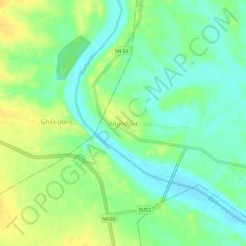
Name: Anandpur topographic map, elevation, terrain.

Location: Anandpur, Anandapur, Kendujhar, Odisha, 756046, India (21.19435 86.10319 21.23435 86.14319)

Average elevation: 43 m

Minimum elevation: 31 m

Maximum elevation: 56 m

Gear up for your next adventure:

🐕Hiking Dog Pack - Let your canine companion carry their own water and food
🥽Outdoor Goggles - Protective eyewear for outdoor activities
🧴Outdoor Sunscreen - High SPF protection for high-altitude UV exposure
🔦UV Flashlight - Detect minerals or specific insects in the dark
💧Reusable Water Bottle - Durable water bottles for hydration on trails

As an Amazon Associate, this site earns from qualifying purchases at no extra cost to you.