Geolocate

Tordera topographic map

Click on the map to display elevation.

About this map

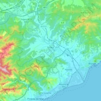
Name: Tordera topographic map, elevation, terrain.

Location: Tordera, Maresme, Barcelona, Catalonia, 08490, Spain (41.64228 2.59366 41.74425 2.77750)

Average elevation: 97 m

Minimum elevation: 0 m

Maximum elevation: 555 m

Other topographic maps

Click on a map to view its topography, its elevation and its terrain.

Palafolls

Spain > Catalonia > Maresme > Palafolls > Palafolls

Average elevation: 26 m

el Masnou

Spain > Catalonia > Maresme > el Masnou > el Masnou

Average elevation: 92 m

Gear up for your next adventure:

🧳Compression Sacks - Maximize space in your backpack by shrinking gear
🧭GPS Outdoor Watch - Smart watch for navigation and fitness tracking in nature
🧦Outdoor Socks - Durable socks designed for hiking and outdoor sports
📷Outdoor Action Camera - Capture high-elevation views and rugged adventures
🔋Emergency Crank Radio - Weather alerts and power without needing batteries

As an Amazon Associate, this site earns from qualifying purchases at no extra cost to you.