Geolocate

Colapon topographic map

Click on the map to display elevation.

About this map

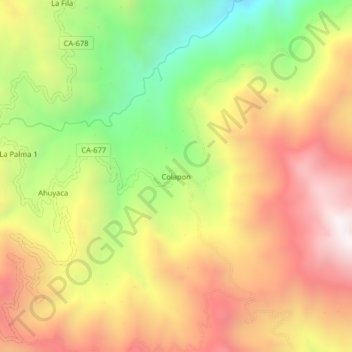
Name: Colapon topographic map, elevation, terrain.

Location: Colapon, Colasay, Jaén, Cajamarca, Perú (-5.95325 -79.00821 -5.91325 -78.96821)

Average elevation: 1,977 m

Minimum elevation: 1,375 m

Maximum elevation: 2,518 m

Other topographic maps

Click on a map to view its topography, its elevation and its terrain.

Río Huancabamba

Perú > Cajamarca > Colasay

Average elevation: 934 m

Gear up for your next adventure:

🧤Insulated Winter Gloves - Heavy-duty protection for sub-zero Canadian adventures
🛰️Satellite Messenger - Emergency communication for areas with no cell service
🧥Softshell Hiking Jacket - The perfect balance of wind protection and breathability
🥾Trail Hiking Boots - Supportive boots for rough trails
🥾Trail Running Shoes - Lightweight and durable shoes for trail running

As an Amazon Associate, this site earns from qualifying purchases at no extra cost to you.