
Make a donation
Gear up for your next adventure:
As an Amazon Associate, this site earns from qualifying purchases at no extra cost to you.
Town of Fishkill topographic map
Click on the map to display elevation.
Make a donation
Gear up for your next adventure:
As an Amazon Associate, this site earns from qualifying purchases at no extra cost to you.
Town of Fishkill
According to the United States Census Bureau, the town has a total area of 32.0 square miles (82.9 km2), of which 27.3 square miles (70.8 km2) is land and 4.7 square miles (12.1 km2), or 14.55%, is water. The elevation of the town varies from sea level along the Hudson River (Fishkill Waterfront, Fishkill Landing, Dutchess Junction) to 1,600 feet (490 m) above sea level (South Beacon Mountain).
Make a donation
Gear up for your next adventure:
As an Amazon Associate, this site earns from qualifying purchases at no extra cost to you.
About this map
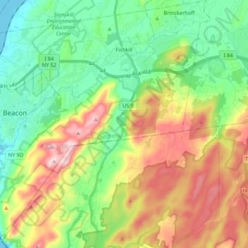
Name: Town of Fishkill topographic map, elevation, terrain.
Location: Town of Fishkill, Dutchess County, New York, United States (41.43901 -74.00135 41.55952 -73.84264)
Average elevation: 178 m
Minimum elevation: -2 m
Maximum elevation: 479 m
Make a donation
Gear up for your next adventure:
As an Amazon Associate, this site earns from qualifying purchases at no extra cost to you.
Other topographic maps
Click on a map to view its topography, its elevation and its terrain.
Make a donation
Gear up for your next adventure:
As an Amazon Associate, this site earns from qualifying purchases at no extra cost to you.
Hydepark Recreations
United States > New York > Dutchess County > Town of Hyde Park
Average elevation: 66 m
Make a donation
Gear up for your next adventure:
As an Amazon Associate, this site earns from qualifying purchases at no extra cost to you.
Make a donation
Gear up for your next adventure:
As an Amazon Associate, this site earns from qualifying purchases at no extra cost to you.
Make a donation
Gear up for your next adventure:
As an Amazon Associate, this site earns from qualifying purchases at no extra cost to you.
Make a donation
Gear up for your next adventure:
As an Amazon Associate, this site earns from qualifying purchases at no extra cost to you.