
Make a donation
Gear up for your next adventure:
As an Amazon Associate, this site earns from qualifying purchases at no extra cost to you.
Arbus topographic map
Click on the map to display elevation.
Make a donation
Gear up for your next adventure:
As an Amazon Associate, this site earns from qualifying purchases at no extra cost to you.
Arbus
These new chronological elements that have been provided by the archeological researches and investigations let Arbus' settlement be added to ancient Sardinian topography. Indeed, until those findings were made, Arbus was thought to have been founded during the Middle Ages, at least according to the documentation of the time. Indeed, the town was not included in the list of the pontifical tithe payments relating to 1341 arguably because, differently from now, the town was actually made up of different separate hamlets such as Santu Domini, Santa Sofia, Bidda Zei, Bidda Erdi, Villa Babari, Funtana Atza, Cilirus in Flumentorgiu, "Villa Jaca" and other minor locations but year after year, also because of the numerous incursions by land and sea carried out by Saracens and Aragonese people, these hamlets' inhabitants eventually ended up living in a single town, which would make for the future town of Arbus.
Make a donation
Gear up for your next adventure:
As an Amazon Associate, this site earns from qualifying purchases at no extra cost to you.
About this map
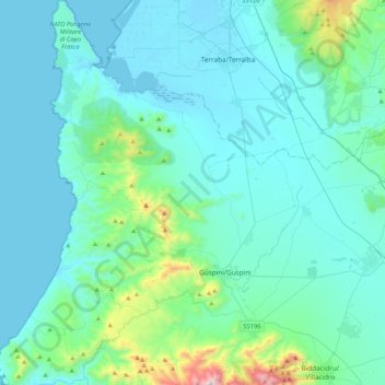
Name: Arbus topographic map, elevation, terrain.
Location: Arbus, Sud Sardegna, Sardinia, 09031, Italy (39.44646 8.37928 39.76972 8.62038)
Average elevation: 138 m
Minimum elevation: -4 m
Maximum elevation: 1,217 m
Make a donation
Gear up for your next adventure:
As an Amazon Associate, this site earns from qualifying purchases at no extra cost to you.
Other topographic maps
Click on a map to view its topography, its elevation and its terrain.
Make a donation
Gear up for your next adventure:
As an Amazon Associate, this site earns from qualifying purchases at no extra cost to you.
Make a donation
Gear up for your next adventure:
As an Amazon Associate, this site earns from qualifying purchases at no extra cost to you.
Make a donation
Gear up for your next adventure:
As an Amazon Associate, this site earns from qualifying purchases at no extra cost to you.
Salmagi
Italy > Sardinia > Casteddu/Cagliari > Quartu Sant'Aleni/Quartu Sant'Elena > Terra Mala
Average elevation: 60 m
Make a donation
Gear up for your next adventure:
As an Amazon Associate, this site earns from qualifying purchases at no extra cost to you.
Make a donation
Gear up for your next adventure:
As an Amazon Associate, this site earns from qualifying purchases at no extra cost to you.
Make a donation
Gear up for your next adventure:
As an Amazon Associate, this site earns from qualifying purchases at no extra cost to you.
Monte Arcosu
Italy > Sardinia > Casteddu/Cagliari > Siliqua
Monte Arcosu is a mountain in the Sulcis massif, in southern Sardinia, Italy. It has an elevation of 948 metres (3,110 ft).
Average elevation: 546 m
Make a donation
Gear up for your next adventure:
As an Amazon Associate, this site earns from qualifying purchases at no extra cost to you.
Torre Grande
Italy > Sardinia > Aristanis/Oristano > Aristanis/Oristano > Torregrande
Average elevation: 1 m
Make a donation
Gear up for your next adventure:
As an Amazon Associate, this site earns from qualifying purchases at no extra cost to you.