
Make a donation
Gear up for your next adventure:
As an Amazon Associate, this site earns from qualifying purchases at no extra cost to you.
Saint-Disdier topographic map
Click on the map to display elevation.
Make a donation
Gear up for your next adventure:
As an Amazon Associate, this site earns from qualifying purchases at no extra cost to you.
About this map
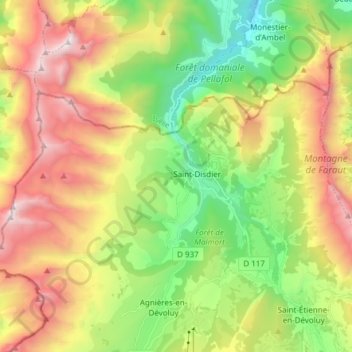
Name: Saint-Disdier topographic map, elevation, terrain.
Average elevation: 1,614 m
Minimum elevation: 749 m
Maximum elevation: 2,770 m
Make a donation
Gear up for your next adventure:
As an Amazon Associate, this site earns from qualifying purchases at no extra cost to you.
Other topographic maps
Click on a map to view its topography, its elevation and its terrain.
Les Hauts Gicons
France > Provence-Alpes-Côte d'Azur > Hautes-Alpes > Le Dévoluy
Average elevation: 1,359 m
Tete d'Oriol
France > Provence-Alpes-Côte d'Azur > Hautes-Alpes > Le Dévoluy
Average elevation: 2,110 m
La Joue du Loup
France > Provence-Alpes-Côte d'Azur > Hautes-Alpes > Le Dévoluy
Average elevation: 1,488 m
Make a donation
Gear up for your next adventure:
As an Amazon Associate, this site earns from qualifying purchases at no extra cost to you.
SuperDévoluy
France > Provence-Alpes-Côte d'Azur > Hautes-Alpes > Le Dévoluy
Average elevation: 1,553 m
Le Grand Villard
France > Provence-Alpes-Côte d'Azur > Hautes-Alpes > Le Dévoluy
Average elevation: 1,346 m
Combe de Bure
France > Provence-Alpes-Côte d'Azur > Hautes-Alpes > Le Dévoluy
Average elevation: 2,089 m
Lachaup
France > Provence-Alpes-Côte d'Azur > Hautes-Alpes > Le Dévoluy > Lachaup
Average elevation: 1,500 m
Make a donation
Gear up for your next adventure:
As an Amazon Associate, this site earns from qualifying purchases at no extra cost to you.
Les Cypières
France > Provence-Alpes-Côte d'Azur > Hautes-Alpes > Le Dévoluy
Average elevation: 1,511 m
Make a donation
Gear up for your next adventure:
As an Amazon Associate, this site earns from qualifying purchases at no extra cost to you.
Tête de la Cluse
France > Provence-Alpes-Côte d'Azur > Hautes-Alpes > Le Dévoluy
Average elevation: 2,166 m
Tête d'Aurouze
France > Provence-Alpes-Côte d'Azur > Hautes-Alpes > Le Dévoluy
Average elevation: 2,159 m
Make a donation
Gear up for your next adventure:
As an Amazon Associate, this site earns from qualifying purchases at no extra cost to you.
Saint-Étienne-en-Dévoluy
France > Provence-Alpes-Côte d'Azur > Hautes-Alpes > Le Dévoluy
Average elevation: 1,500 m
Vallon des Narites
France > Provence-Alpes-Côte d'Azur > Hautes-Alpes > Le Dévoluy
Average elevation: 1,940 m
Make a donation
Gear up for your next adventure:
As an Amazon Associate, this site earns from qualifying purchases at no extra cost to you.
Le Cousy
France > Provence-Alpes-Côte d'Azur > Hautes-Alpes > Le Dévoluy > Le Cousy
Average elevation: 1,402 m
Villard Joli
France > Provence-Alpes-Côte d'Azur > Hautes-Alpes > Le Dévoluy
Average elevation: 1,329 m
Make a donation
Gear up for your next adventure:
As an Amazon Associate, this site earns from qualifying purchases at no extra cost to you.
Vallon d'Ane
France > Provence-Alpes-Côte d'Azur > Hautes-Alpes > Le Dévoluy
Average elevation: 1,947 m
Le Moulin du Vaysseau
France > Provence-Alpes-Côte d'Azur > Hautes-Alpes > Le Dévoluy
Average elevation: 1,355 m
Make a donation
Gear up for your next adventure:
As an Amazon Associate, this site earns from qualifying purchases at no extra cost to you.
L'Ubac des Garcins
France > Provence-Alpes-Côte d'Azur > Hautes-Alpes > Le Dévoluy
Average elevation: 1,592 m
Agnières-en-Dévoluy
France > Provence-Alpes-Côte d'Azur > Hautes-Alpes > Le Dévoluy
L'altitude élevée de ce territoire fait que le climat y est très marqué : un hiver rigoureux et long pouvant être tour à tour sec et froid ou parfois plus humide, ce qui peut entraîner de fortes chutes de neige. L'été y est particulièrement agréable, la fraîcheur du soir venant tempérer des…
Average elevation: 1,425 m
La Combe de l'Eau
France > Provence-Alpes-Côte d'Azur > Hautes-Alpes > Le Dévoluy
Average elevation: 1,314 m
Make a donation
Gear up for your next adventure:
As an Amazon Associate, this site earns from qualifying purchases at no extra cost to you.
Les Bas Gicons
France > Provence-Alpes-Côte d'Azur > Hautes-Alpes > Le Dévoluy
Average elevation: 1,345 m
Saint-Étienne-en-Dévoluy
France > Provence-Alpes-Côte d'Azur > Hautes-Alpes > Le Dévoluy
Average elevation: 1,500 m
Make a donation
Gear up for your next adventure:
As an Amazon Associate, this site earns from qualifying purchases at no extra cost to you.