
Make a donation
Gear up for your next adventure:
As an Amazon Associate, this site earns from qualifying purchases at no extra cost to you.
Vagliagli topographic map
Click on the map to display elevation.
Make a donation
Gear up for your next adventure:
As an Amazon Associate, this site earns from qualifying purchases at no extra cost to you.
About this map
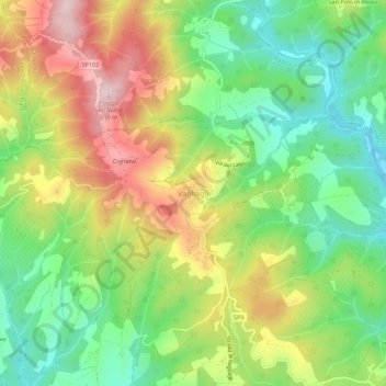
Name: Vagliagli topographic map, elevation, terrain.
Location: Vagliagli, Castelnuovo Berardenga, Siena, Toskana, Italien (43.40164 11.32807 43.44164 11.36807)
Average elevation: 429 m
Minimum elevation: 288 m
Maximum elevation: 618 m
Make a donation
Gear up for your next adventure:
As an Amazon Associate, this site earns from qualifying purchases at no extra cost to you.
Other topographic maps
Click on a map to view its topography, its elevation and its terrain.
San Quirico d'Orcia
Das ist auch am typisch gotischen Dekorationsband zu erkennen, das sich an den französischen Kathedralfassaden in der Höhe der Kapitelle der Ecksäulen über die ganze Portalzone zu beiden Seiten hinzieht.
Average elevation: 318 m
Asciano
Die Stadt Asciano liegt etwa 100 km südöstlich der Regionalhauptstadt Florenz und rund 25 km südöstlich der Provinzhauptstadt Siena. Sie ist Hauptort der Crete Senesi, eines Landstrichs, der benannt ist nach der hellen Erde, die dort vorkommt, und liegt in der klimatischen Einordnung italienischer…
Average elevation: 285 m
Make a donation
Gear up for your next adventure:
As an Amazon Associate, this site earns from qualifying purchases at no extra cost to you.
San Quirico d'Orcia
Das ist auch am typisch gotischen Dekorationsband zu erkennen, das sich an den französischen Kathedralfassaden in der Höhe der Kapitelle der Ecksäulen über die ganze Portalzone zu beiden Seiten hinzieht.
Average elevation: 318 m
San Gimignano
Der historische Stadtkern ist seit dem Jahr 1990 Teil des Weltkulturerbes der UNESCO. San Gimignano besitzt noch einige der mittelalterlichen Geschlechtertürme, die in anderen Städten nur als Stümpfe erhalten blieben. Im Mittelalter versuchten die Patrizierfamilien, sich in der Höhe ihres…
Average elevation: 239 m
Make a donation
Gear up for your next adventure:
As an Amazon Associate, this site earns from qualifying purchases at no extra cost to you.
Make a donation
Gear up for your next adventure:
As an Amazon Associate, this site earns from qualifying purchases at no extra cost to you.
Abbadia San Salvatore
Der Ort am Südhang des Monte Amiata erstreckt sich über 58,9 km². Er liegt etwa 60 km südöstlich der Provinzhauptstadt Siena und ca. 110 km südöstlich der Regionalhauptstadt Florenz. Das Gipfelkreuz des Monte Amiata liegt auf dem Gemeindegebiet von Abbadia San Salvatore und wurde 1910 mit einer Höhe…
Average elevation: 831 m
Poggibonsi
Der heutige Ort entstand im 10. Jahrhundert unter dem Namen Borgo di Marte (später Borgo di Marturi) als Borgo unterhalb der Burg und Abtei Castello della Badia, die auf der Anhöhe Poggio Marturi liegt. In der Mitte des 12. Jahrhunderts entstand auf der Anhöhe Poggiobonizio (benannt nach Bonizzo Segni,…
Average elevation: 189 m
Make a donation
Gear up for your next adventure:
As an Amazon Associate, this site earns from qualifying purchases at no extra cost to you.