
Make a donation
Gear up for your next adventure:
As an Amazon Associate, this site earns from qualifying purchases at no extra cost to you.
Chinhoyi topographic map
Click on the map to display elevation.
Make a donation
Gear up for your next adventure:
As an Amazon Associate, this site earns from qualifying purchases at no extra cost to you.
Chinhoyi
The geographical coordinates of Chinhoyi are:17°20'59.0"S, 30°11'40.0"E (Latitude:-17.349722; Longitude:30.194444). Chinhoyi sits at an average elevation of 1,187 metres (3,894 ft) above mean sea level.
Make a donation
Gear up for your next adventure:
As an Amazon Associate, this site earns from qualifying purchases at no extra cost to you.
About this map
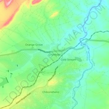
Name: Chinhoyi topographic map, elevation, terrain.
Location: Chinhoyi, Makonde, Mashonaland West Province, Zimbabwe (-17.40153 30.15294 -17.32153 30.23294)
Average elevation: 1,167 m
Minimum elevation: 1,101 m
Maximum elevation: 1,346 m
Make a donation
Gear up for your next adventure:
As an Amazon Associate, this site earns from qualifying purchases at no extra cost to you.