
Make a donation
Gear up for your next adventure:
As an Amazon Associate, this site earns from qualifying purchases at no extra cost to you.
El Endrinal topographic map
Click on the map to display elevation.
Make a donation
Gear up for your next adventure:
As an Amazon Associate, this site earns from qualifying purchases at no extra cost to you.
About this map
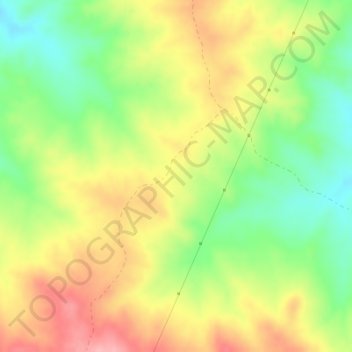
Name: El Endrinal topographic map, elevation, terrain.
Location: El Endrinal, Cardeña, Córdoba, Andalucía, España (38.29147 -4.40240 38.31147 -4.38240)
Average elevation: 739 m
Minimum elevation: 682 m
Maximum elevation: 798 m
Make a donation
Gear up for your next adventure:
As an Amazon Associate, this site earns from qualifying purchases at no extra cost to you.
Other topographic maps
Click on a map to view its topography, its elevation and its terrain.
Cardeña
Cardeña es un municipio y localidad española del norte de la provincia de Córdoba, en Andalucía. El término municipal, que incluye las localidades de Cardeña, Venta del Charco y Azuel, cuenta con una población de 1473 habitantes (INE 2021). Se encuentra situada a una altitud de 821 m sobre el nivel del mar.
Average elevation: 648 m