
Thank you for supporting this site ❤️
Make a donation
Make a donation
Gear up for your next adventure:
As an Amazon Associate, this site earns from qualifying purchases at no extra cost to you.
Campaegli topographic map
Click on the map to display elevation.
Thank you for supporting this site ❤️
Make a donation
Make a donation
Gear up for your next adventure:
As an Amazon Associate, this site earns from qualifying purchases at no extra cost to you.
About this map
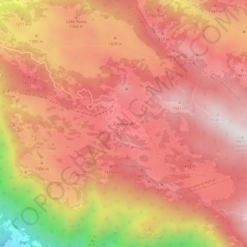
Name: Campaegli topographic map, elevation, terrain.
Location: Campaegli, Cervara di Roma, Roma, Lazio, 00028, Italia (41.95155 13.08717 41.99155 13.12717)
Average elevation: 1,319 m
Minimum elevation: 679 m
Maximum elevation: 1,602 m
Thank you for supporting this site ❤️
Make a donation
Make a donation
Gear up for your next adventure:
As an Amazon Associate, this site earns from qualifying purchases at no extra cost to you.