Geolocate

Rudolphstein topographic map

Click on the map to display elevation.

About this map

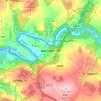
Name: Rudolphstein topographic map, elevation, terrain.

Location: Rudolphstein, Berg, Landkreis Hof, Bavaria, 95180, Germany (50.38933 11.75117 50.42933 11.79117)

Average elevation: 519 m

Minimum elevation: 420 m

Maximum elevation: 622 m

Other topographic maps

Click on a map to view its topography, its elevation and its terrain.

Bad Steben

Germany > Bavaria > Landkreis Hof

Average elevation: 595 m

Münchberg

Germany > Bavaria > Landkreis Hof

Average elevation: 581 m

Naila

Germany > Bavaria > Landkreis Hof

Average elevation: 581 m

Gear up for your next adventure:

🧤Insulated Winter Gloves - Heavy-duty protection for sub-zero Canadian adventures
Camping Coffee Maker - Brew fresh coffee anywhere on the topographic map
💧Hydration Bladder - Hands-free hydration solution for long treks
🦶Anti-Blister Balm - Prevents friction and hotspots during long ascents
🛏️Camping Sleeping Mat - Comfortable mats for sleeping outdoors

As an Amazon Associate, this site earns from qualifying purchases at no extra cost to you.