Geolocate

Celanova topographic map

Click on the map to display elevation.

About this map

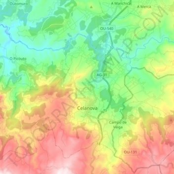
Name: Celanova topographic map, elevation, terrain.

Location: Celanova, Terra da Celanova, Ourense, Galicia, Spain (42.11528 -8.06270 42.21797 -7.89968)

Average elevation: 535 m

Minimum elevation: 276 m

Maximum elevation: 944 m

Other topographic maps

Click on a map to view its topography, its elevation and its terrain.

San Roque de Crespos

Spain > Galicia > Terra da Celanova

Average elevation: 365 m

Gear up for your next adventure:

🧴First Aid Kit - Essential first aid supplies for outdoor emergencies
🕶️Polarized Sunglasses - Reduces glare from snow and water at high elevations
Lightweight Backpacking Tent - Compact tent for efficient hiking trips
🎒Fully Waterproof Backpack - Total protection for photography gear and electronics
🦶Anti-Blister Balm - Prevents friction and hotspots during long ascents

As an Amazon Associate, this site earns from qualifying purchases at no extra cost to you.