
Chancé topographic map
Interactive map
Click on the map to display elevation.
About this map
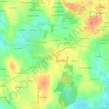
Name: Chancé topographic map, elevation, terrain.
Average elevation: 70 m
Minimum elevation: 46 m
Maximum elevation: 94 m
Other topographic maps
Click on a map to view its topography, its elevation and its terrain.
La Rivière
France > Bretagne > Piré-Chancé
La Rivière, Piré-sur-Seiche, Piré-Chancé, Rennes, Ille-et-Vilaine, Bretagne, France métropolitaine, 35150, France
Average elevation: 57 m