Geolocate

Copper Mountain topographic map

Click on the map to display elevation.

About this map

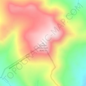
Name: Copper Mountain topographic map, elevation, terrain.

Location: Copper Mountain, Mineral County, Colorado, United States (37.69968 -106.88593 37.69978 -106.88583)

Average elevation: 3,384 m

Minimum elevation: 3,073 m

Maximum elevation: 3,646 m

Gear up for your next adventure:

👟Trail Running Shoes - Agile footwear for fast-paced topographic exploration
🧢Sun Protection Cap - Breathable cap to protect from sun exposure
🛌Down Sleeping Bag - Superior warmth-to-weight ratio for cold nights
🧢Outdoor Visor - Breathable visor for sunny hikes
💡Solar Camping Lamp - Eco-friendly lighting for campsites

As an Amazon Associate, this site earns from qualifying purchases at no extra cost to you.