
Make a donation
Gear up for your next adventure:
As an Amazon Associate, this site earns from qualifying purchases at no extra cost to you.
Waukegan topographic map
Click on the map to display elevation.
Make a donation
Gear up for your next adventure:
As an Amazon Associate, this site earns from qualifying purchases at no extra cost to you.
Waukegan
Waukegan is located at 42°22′13″N 87°52′16″W / 42.37028°N 87.87111°W / 42.37028; -87.87111 (42.3703140, −87.8711404). Waukegan is on the shore of Lake Michigan, about 11 miles (18 km) south of the border with Wisconsin and 37 miles (60 km) north of downtown Chicago at an elevation around 650 feet (200 m) above sea level. Chicago has two major streets that venture north to Waukegan, one being Sheridan Road, which extends north from Diversey Parkway in Lincoln Park. The second street is Milwaukee Avenue, which starts at the intersection of Desplaines Street and Kinzie Street in downtown Chicago.
Make a donation
Gear up for your next adventure:
As an Amazon Associate, this site earns from qualifying purchases at no extra cost to you.
About this map
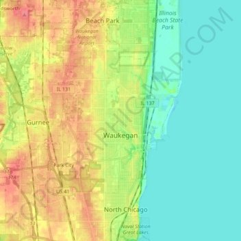
Name: Waukegan topographic map, elevation, terrain.
Location: Waukegan, Lake County, Illinois, United States (42.30938 -87.96442 42.43266 -87.80421)
Average elevation: 197 m
Minimum elevation: 172 m
Maximum elevation: 236 m
Make a donation
Gear up for your next adventure:
As an Amazon Associate, this site earns from qualifying purchases at no extra cost to you.
Other topographic maps
Click on a map to view its topography, its elevation and its terrain.
Make a donation
Gear up for your next adventure:
As an Amazon Associate, this site earns from qualifying purchases at no extra cost to you.
Make a donation
Gear up for your next adventure:
As an Amazon Associate, this site earns from qualifying purchases at no extra cost to you.
Bishops Ridge
United States > Illinois > Lake County > Kildeer > Bishops Ridge
Average elevation: 253 m
Make a donation
Gear up for your next adventure:
As an Amazon Associate, this site earns from qualifying purchases at no extra cost to you.
Lake Naomi
United States > Illinois > Lake County > Hawthorn Woods > White Birch Lakes
Average elevation: 261 m