
Make a donation
Gear up for your next adventure:
As an Amazon Associate, this site earns from qualifying purchases at no extra cost to you.
Ammelbruch topographic map
Click on the map to display elevation.
Make a donation
Gear up for your next adventure:
As an Amazon Associate, this site earns from qualifying purchases at no extra cost to you.
About this map
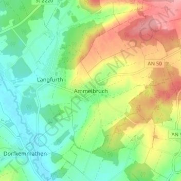
Name: Ammelbruch topographic map, elevation, terrain.
Average elevation: 470 m
Minimum elevation: 430 m
Maximum elevation: 531 m
Make a donation
Gear up for your next adventure:
As an Amazon Associate, this site earns from qualifying purchases at no extra cost to you.
Other topographic maps
Click on a map to view its topography, its elevation and its terrain.
Weihenzell
Deutschland > Bayern > Landkreis Ansbach
Die Gemeinde liegt sieben Kilometer nordöstlich von Ansbach im Naturpark Frankenhöhe. In der Ortsmitte vereinigen sich der Zellbach und der Wernsbach und bilden die Rippach, die in Richtung Ostsüdost zum Haselbach fließt.
Average elevation: 426 m
Make a donation
Gear up for your next adventure:
As an Amazon Associate, this site earns from qualifying purchases at no extra cost to you.
Insingen
Deutschland > Bayern > Landkreis Ansbach
Die Gemeinde liegt im Naturpark Frankenhöhe.
Average elevation: 419 m
Rügland
Deutschland > Bayern > Landkreis Ansbach
Rügland liegt im Naturpark Frankenhöhe.
Average elevation: 422 m
Make a donation
Gear up for your next adventure:
As an Amazon Associate, this site earns from qualifying purchases at no extra cost to you.