Geolocate

Dikos topographic map

Click on the map to display elevation.

About this map

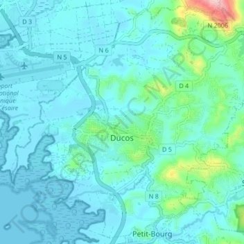
Name: Dikos topographic map, elevation, terrain.

Location: Dikos, Le Marin, Martinique, 97224, France (14.54750 -61.00224 14.60966 -60.93472)

Average elevation: 32 m

Minimum elevation: -1 m

Maximum elevation: 243 m

Other topographic maps

Click on a map to view its topography, its elevation and its terrain.

Canton Suisse

France > Martinique > Le Morne-Vert

Average elevation: 337 m

Baie de Fort-de-France

France > Martinique

Average elevation: 0 m

Domaine du Grand Macabou

France > Martinique > Le Marin

Average elevation: 19 m

Gear up for your next adventure:

🥾Hiking Boots - Sturdy boots providing ankle support and traction on rugged trails
🧭GPS Tracker - Track your location in remote areas safely
🧴Insect Repellent - Protect yourself from bugs during outdoor adventures
🕯️Camping Lantern - Illuminates your entire campsite with high-efficiency LEDs
📷Outdoor Action Camera - Capture high-elevation views and rugged adventures

As an Amazon Associate, this site earns from qualifying purchases at no extra cost to you.