
Make a donation
Gear up for your next adventure:
As an Amazon Associate, this site earns from qualifying purchases at no extra cost to you.
Altenaffeln topographic map
Click on the map to display elevation.
Make a donation
Gear up for your next adventure:
As an Amazon Associate, this site earns from qualifying purchases at no extra cost to you.
Altenaffeln
Der Namensursprung Affelns ist höchstwahrscheinlich den Worten „auf der Lenne“ zurückzuschreiben. Diese Wortwahl drückt ganz klar aus, dass der Ort Affeln gegenüber der Lenne deutlich höher gelegen ist. Dies spielt geradewegs darauf an, dass man sagt, dass die Lenne das Sauerland von dem Hochsauerland trennt, so dass Affeln auf Seiten des Hochsauerlands liegt. Aus dem plattdeutschen „Affelenn“, was so viel heißt wie „auf der Lenne“, wurde später „Affeln“. Ein anderer Namensursprung besagt, dass der Name Affeln von „Apfel“ oder vom „Apfelbaum“ herzuleiten sei. Jedoch ist der genaue Namensursprung bis heute unklar.
Make a donation
Gear up for your next adventure:
As an Amazon Associate, this site earns from qualifying purchases at no extra cost to you.
About this map
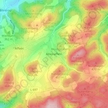
Name: Altenaffeln topographic map, elevation, terrain.
Average elevation: 403 m
Minimum elevation: 284 m
Maximum elevation: 511 m
Make a donation
Gear up for your next adventure:
As an Amazon Associate, this site earns from qualifying purchases at no extra cost to you.