
Make a donation
Gear up for your next adventure:
As an Amazon Associate, this site earns from qualifying purchases at no extra cost to you.
Ighil Ali topographic map
Click on the map to display elevation.
Make a donation
Gear up for your next adventure:
As an Amazon Associate, this site earns from qualifying purchases at no extra cost to you.
About this map
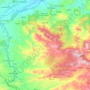
Name: Ighil Ali topographic map, elevation, terrain.
Location: Ighil Ali, Daïra Ighil Ali, Béjaïa, 06014, Algérie (36.21760 4.38948 36.36426 4.62447)
Average elevation: 629 m
Minimum elevation: 215 m
Maximum elevation: 1,308 m
Make a donation
Gear up for your next adventure:
As an Amazon Associate, this site earns from qualifying purchases at no extra cost to you.
Other topographic maps
Click on a map to view its topography, its elevation and its terrain.
Kalâa des Beni Abbès
Algérie > Béjaïa > Daïra Ighil Ali > Ighil Ali
La Kalâa, épousant le relief (en forme de cœur) est bâtie sur un plateau rocheux d'une superficie de 400 hectares dans la chaîne des Bibans, à près de 1 000 mètres d'altitude.
Average elevation: 828 m
Ighil el Djamaâ
Algérie > Béjaïa > Daïra Ighil Ali > Ighil Ali > Kalâa des Beni Abbès
Average elevation: 782 m
Make a donation
Gear up for your next adventure:
As an Amazon Associate, this site earns from qualifying purchases at no extra cost to you.