Geolocate

Patewadi topographic map

Click on the map to display elevation.

About this map

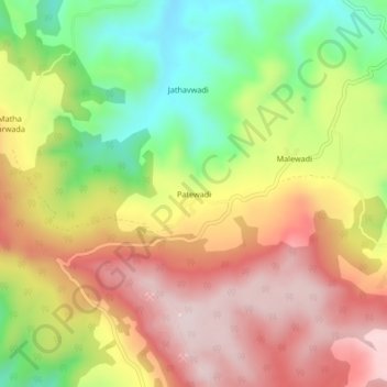
Name: Patewadi topographic map, elevation, terrain.

Location: Patewadi, Shahuwadi, Kolhapur District, Maharashtra, India (16.82987 73.88434 16.86987 73.92434)

Average elevation: 815 m

Minimum elevation: 601 m

Maximum elevation: 1,007 m

Other topographic maps

Click on a map to view its topography, its elevation and its terrain.

Panhala Fort

India > Maharashtra > Shahuwadi > Panhala

Average elevation: 825 m

Panhala Fort

India > Maharashtra > Shahuwadi > Panhala

Average elevation: 825 m

Gear up for your next adventure:

🦟Insect Repellent - Keep mosquitoes and black flies away in wooded areas
🦯Trekking Poles - Reduced impact on joints for steep topographic climbs
🧤Insulated Winter Gloves - Heavy-duty protection for sub-zero Canadian adventures
🥾Lightweight Hiking Boots - Boots for comfort and mobility on long hikes
🧣Merino Neck Gaiter - Protects against wind, sun, and cold at high altitudes

As an Amazon Associate, this site earns from qualifying purchases at no extra cost to you.