Geolocate

Molave topographic map

Click on the map to display elevation.

Molave

Molave is divided into two topographical areas. The east and southwest lowlands, which cover 30 percent of its total land area, consist of nine barangays and are generally flat, swampy and marshy. The upland, which covers 70 percent of Molave's total area, is hilly and mostly deforested. The terrain is moderately sloping to rolling, with the overall grade varying from 10 percent in the lowlands to 27 percent in the mountains.

Wikipedia (CC-BY-SA 3.0)

About this map

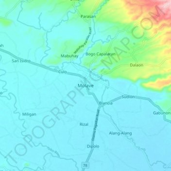
Name: Molave topographic map, elevation, terrain.

Location: Molave, Zamboanga del Sur, Zamboanga Peninsula, 7023, Philippines (8.05277 123.44492 8.13277 123.52492)

Average elevation: 41 m

Minimum elevation: 10 m

Maximum elevation: 240 m

Other topographic maps

Click on a map to view its topography, its elevation and its terrain.

Sominot

Philippines > Zamboanga del Sur

Average elevation: 261 m

Midsalip

Philippines > Zamboanga del Sur

Average elevation: 363 m

Midsalip

Philippines > Zamboanga del Sur

Average elevation: 363 m

Gear up for your next adventure:

🧥Ultralight Puffy Jacket - Maximum warmth that packs down to the size of an orange
Lightweight Camping Tent - Portable shelter optimized for Canadian backcountry camping
🥾Lightweight Hiking Shoes - Comfortable shoes for day hikes
Camping Coffee Maker - Brew fresh coffee anywhere on the topographic map
Family Camping Tent - Spacious tent suitable for family camping trips

As an Amazon Associate, this site earns from qualifying purchases at no extra cost to you.