
Make a donation
Gear up for your next adventure:
As an Amazon Associate, this site earns from qualifying purchases at no extra cost to you.
Bassevelde topographic map
Click on the map to display elevation.
Make a donation
Gear up for your next adventure:
As an Amazon Associate, this site earns from qualifying purchases at no extra cost to you.
Bassevelde
Bassevelde ligt op de grens van het Vlaamse poldergebied en Zandig Vlaanderen, in het Meetjesland. De Lembeekse Isabellabeek is een belangrijke waterloop. De hoogte bedraagt ongeveer 5 meter.
Make a donation
Gear up for your next adventure:
As an Amazon Associate, this site earns from qualifying purchases at no extra cost to you.
About this map
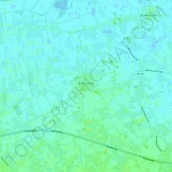
Name: Bassevelde topographic map, elevation, terrain.
Location: Bassevelde, Assenede, Eeklo, Oost-Vlaanderen, 9968, België (51.20477 3.61253 51.25528 3.71981)
Average elevation: 3 m
Minimum elevation: -1 m
Maximum elevation: 9 m
Make a donation
Gear up for your next adventure:
As an Amazon Associate, this site earns from qualifying purchases at no extra cost to you.
Other topographic maps
Click on a map to view its topography, its elevation and its terrain.