
Make a donation
Gear up for your next adventure:
As an Amazon Associate, this site earns from qualifying purchases at no extra cost to you.
Coiric topographic map
Click on the map to display elevation.
Make a donation
Gear up for your next adventure:
As an Amazon Associate, this site earns from qualifying purchases at no extra cost to you.
About this map
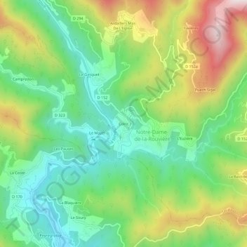
Name: Coiric topographic map, elevation, terrain.
Average elevation: 459 m
Minimum elevation: 232 m
Maximum elevation: 845 m
Make a donation
Gear up for your next adventure:
As an Amazon Associate, this site earns from qualifying purchases at no extra cost to you.
Other topographic maps
Click on a map to view its topography, its elevation and its terrain.
Valleraugue
France > Occitanie > Gard > Val-d'Aigoual
Valleraugue est l'une des communes du Massif central où le dénivelé entre le point le plus haut et le point le plus bas est le plus important (près de 1 300 mètres). Le plus haut hameau de la commune est L'Espérou, situé à 1 200 mètres d'altitude.
Average elevation: 790 m
Observatoire Météorologique du Mont Aigoual
France > Occitanie > Gard > Val-d'Aigoual
Average elevation: 1,352 m