Geolocate

Ryde topographic map

Click on the map to display elevation.

About this map

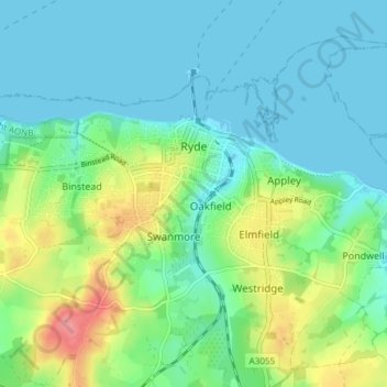
Name: Ryde topographic map, elevation, terrain.

Location: Ryde, Isle of Wight, England, United Kingdom (50.70567 -1.20765 50.74260 -1.13284)

Average elevation: 21 m

Minimum elevation: 0 m

Maximum elevation: 79 m

Other topographic maps

Click on a map to view its topography, its elevation and its terrain.

Gear up for your next adventure:

🧰Survival Kit - Essential gear for emergencies in the wilderness
🍽️Titanium Camping Spork - Ultralight and indestructible eating utensil
🥾Trail Hiking Socks - Comfortable socks to prevent blisters and fatigue
🧥Softshell Jacket - Windproof and breathable jacket for hiking
🚲Handlebar Phone Mount - View topographic-map.com live while cycling

As an Amazon Associate, this site earns from qualifying purchases at no extra cost to you.