Geolocate

Mow Cop topographic map

Click on the map to display elevation.

About this map
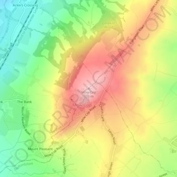
Name: Mow Cop topographic map, elevation, terrain.

Location: Mow Cop, Cheshire East, England, ST7 3PG, United Kingdom (53.11485 -2.21307 53.11495 -2.21297)

Average elevation: 220 m

Minimum elevation: 112 m

Maximum elevation: 330 m

Other topographic maps

Click on a map to view its topography, its elevation and its terrain.

Audlem

United Kingdom > England > Cheshire East

Average elevation: 72 m

Alderley Edge

United Kingdom > England > Cheshire East > Alderley Edge

Alderley Edge is 6 miles (10 km) northwest of Macclesfield and 12 miles (19 km) south of Manchester, at the base of a steep and thickly wooded sandstone escarpment, Alderley Edge, which is the area's chief topographical feature and overlooks the Cheshire Plain.

Average elevation: 91 m

Norbury

United Kingdom > England > Cheshire East

Average elevation: 82 m

Knutsford

United Kingdom > England > Cheshire East

Average elevation: 58 m

Wilmslow

United Kingdom > England > Cheshire East

Average elevation: 81 m

Smallwood

United Kingdom > England > Cheshire East

Average elevation: 86 m

Nantwich

United Kingdom > England > Cheshire East

Average elevation: 45 m

Gear up for your next adventure:

🛏️Camping Sleeping Mat - Comfortable mats for sleeping outdoors
🏃Hydration Running Vest - Carry water and maps close to your body for speed
🧥Thermal Fleece Jacket - Versatile insulation for changing mountain temperatures
🔥Camping Stove - Portable stoves to cook outdoors with ease
🧦Thermal Socks - Warm socks for winter hiking or camping

As an Amazon Associate, this site earns from qualifying purchases at no extra cost to you.