
The Copilot topographic map
Click on the map to display elevation.
About this map
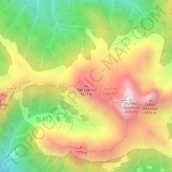
Name: The Copilot topographic map, elevation, terrain.
Average elevation: 1,468 m
Minimum elevation: 941 m
Maximum elevation: 1,996 m
Other topographic maps
Click on a map to view its topography, its elevation and its terrain.
Daisy Lake
Canada > British Columbia > Squamish-Lillooet Regional District > Area D (Elaho/Garibaldi)
Average elevation: 621 m
Garibaldi Lake
Canada > British Columbia > Squamish-Lillooet Regional District > Area D (Elaho/Garibaldi)
All recreational activities in the area are governed by the regulations of Garibaldi Provincial Park. Primary access to the lake is via the 9 km (5.6 mi) long Garibaldi Lake Trail, which gains approximately 920 m (3,020 ft) of elevation from the Rubble Creek Trailhead. There are campgrounds and day-use…
Average elevation: 1,620 m