
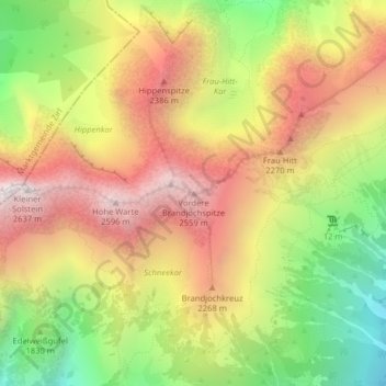
Vordere Brandjochspitze topographic map
Interactive map
Click on the map to display elevation.
About this map
Name: Vordere Brandjochspitze topographic map, elevation, terrain.
Average elevation: 1,987 m
Minimum elevation: 1,289 m
Maximum elevation: 2,619 m
La Vordere Brandjochspitze est une montagne qui s’élève à 2 559 m d’altitude dans les Karwendel, en Autriche.
Other topographic maps
Click on a map to view its topography, its elevation and its terrain.