Geolocate

Aciera topographic map

Click on the map to display elevation.

About this map

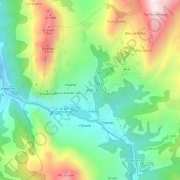
Name: Aciera topographic map, elevation, terrain.

Location: Aciera, Quirós, Asturias, 33118, España (43.18411 -6.02772 43.22411 -5.98772)

Average elevation: 663 m

Minimum elevation: 271 m

Maximum elevation: 1,334 m

Gear up for your next adventure:

🧴Sunscreen SPF - Broad-spectrum sunscreen for outdoor activities
🔦LED Headtorch - Bright and durable light for night activities
🧥Packable Rain Jacket - Breathable waterproof layer for unpredictable weather
🎒Backpack Rain Cover - External shield to keep your entire pack dry
🚲Handlebar Phone Mount - View topographic-map.com live while cycling

As an Amazon Associate, this site earns from qualifying purchases at no extra cost to you.