
Make a donation
Gear up for your next adventure:
As an Amazon Associate, this site earns from qualifying purchases at no extra cost to you.
Spitskop topographic map
Click on the map to display elevation.
Make a donation
Gear up for your next adventure:
As an Amazon Associate, this site earns from qualifying purchases at no extra cost to you.
About this map
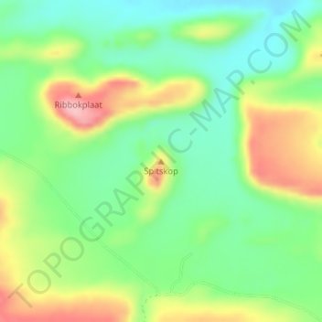
Name: Spitskop topographic map, elevation, terrain.
Average elevation: 541 m
Minimum elevation: 479 m
Maximum elevation: 639 m
Make a donation
Gear up for your next adventure:
As an Amazon Associate, this site earns from qualifying purchases at no extra cost to you.
Other topographic maps
Click on a map to view its topography, its elevation and its terrain.
Klip River
South Africa > Western Cape > Overberg District Municipality > Swellendam Local Municipality > Swellendam
Average elevation: 324 m
Suurbraak
South Africa > Western Cape > Overberg District Municipality > Swellendam Local Municipality
Average elevation: 171 m
Boosmansbos
South Africa > Western Cape > Overberg District Municipality > Swellendam Local Municipality
Average elevation: 1,123 m