Geolocate

Matamá topographic map

Click on the map to display elevation.

About this map

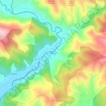
Name: Matamá topographic map, elevation, terrain.

Location: Matamá, Laza, Verín, Orense, Galicia, 32621, España (42.01556 -7.45351 42.05556 -7.41351)

Average elevation: 573 m

Minimum elevation: 418 m

Maximum elevation: 787 m

Other topographic maps

Click on a map to view its topography, its elevation and its terrain.

A Alberguería

España > Galicia > Verín > Laza

Average elevation: 863 m

Cerdedelo

España > Galicia > Verín > Laza

Average elevation: 933 m

Gear up for your next adventure:

🧴Bear Spray Holster - Quick-access carry for essential Canadian wilderness safety
🧤Insulated Winter Gloves - Heavy-duty protection for sub-zero Canadian adventures
🛰️Satellite Messenger - Emergency communication for areas with no cell service
🚲Handlebar Phone Mount - View topographic-map.com live while cycling
👖Convertible Hiking Pants - Zip-off legs to adapt to changing weather conditions

As an Amazon Associate, this site earns from qualifying purchases at no extra cost to you.