
Make a donation
Gear up for your next adventure:
As an Amazon Associate, this site earns from qualifying purchases at no extra cost to you.
Escalos de Cima topographic map
Click on the map to display elevation.
Make a donation
Gear up for your next adventure:
As an Amazon Associate, this site earns from qualifying purchases at no extra cost to you.
About this map
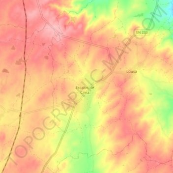
Name: Escalos de Cima topographic map, elevation, terrain.
Location: Escalos de Cima, Castelo Branco, 6005-170, Portugal (39.89819 -7.42384 39.96372 -7.38052)
Average elevation: 366 m
Minimum elevation: 284 m
Maximum elevation: 412 m
Make a donation
Gear up for your next adventure:
As an Amazon Associate, this site earns from qualifying purchases at no extra cost to you.
Other topographic maps
Click on a map to view its topography, its elevation and its terrain.
Coutoda Serrinha
Portugal > Castelo Branco > Castelo Branco > Monforte da Beira
Average elevation: 220 m
Make a donation
Gear up for your next adventure:
As an Amazon Associate, this site earns from qualifying purchases at no extra cost to you.
Fontelonga
Portugal > Castelo Branco > Castelo Branco > Santo André das Tojeiras
Average elevation: 313 m
Garridas
Portugal > Castelo Branco > Castelo Branco > Santo André das Tojeiras
Average elevation: 323 m
Make a donation
Gear up for your next adventure:
As an Amazon Associate, this site earns from qualifying purchases at no extra cost to you.