
Sugar Mountain topographic map
Interactive map
Click on the map to display elevation.
About this map
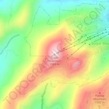
Name: Sugar Mountain topographic map, elevation, terrain.
Average elevation: 1,385 m
Minimum elevation: 1,211 m
Maximum elevation: 1,584 m
Sugar Mountain is a mountain in the North Carolina High Country and wholly in the Pisgah National Forest. Its elevation reaches 5,236 feet (1,596 m) and is split along the Eastern Continental Divide, generating feeder streams for the Linville, Elk, and North Toe rivers. On its north slope resides the Village of Sugar Mountain.