
Thank you for supporting this site ❤️
Make a donation
Make a donation
Gear up for your next adventure:
As an Amazon Associate, this site earns from qualifying purchases at no extra cost to you.
Dignac topographic map
Click on the map to display elevation.
Thank you for supporting this site ❤️
Make a donation
Make a donation
Gear up for your next adventure:
As an Amazon Associate, this site earns from qualifying purchases at no extra cost to you.
Dignac
Le point le plus bas de la commune est à une altitude de 105 m, situé le long de l'Échelle sur la limite nord-est. Le bourg, situé sur une légère hauteur dominant la vallée naissante de l'Échelle, est à environ 170 m d'altitude.
Thank you for supporting this site ❤️
Make a donation
Make a donation
Gear up for your next adventure:
As an Amazon Associate, this site earns from qualifying purchases at no extra cost to you.
About this map
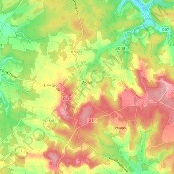
Name: Dignac topographic map, elevation, terrain.
Average elevation: 162 m
Minimum elevation: 92 m
Maximum elevation: 227 m
Thank you for supporting this site ❤️
Make a donation
Make a donation
Gear up for your next adventure:
As an Amazon Associate, this site earns from qualifying purchases at no extra cost to you.