Geolocate

Panama City topographic map

Click on the map to display elevation.

About this map

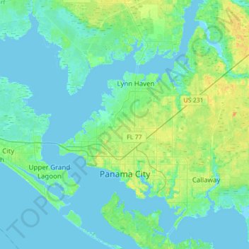
Name: Panama City topographic map, elevation, terrain.

Location: Panama City, Bay County, Florida, United States (30.13407 -85.73734 30.27760 -85.46070)

Average elevation: 6 m

Minimum elevation: -5 m

Maximum elevation: 24 m

Other topographic maps

Click on a map to view its topography, its elevation and its terrain.

Fountain

United States > Florida > Bay County

Average elevation: 51 m

Millville

United States > Florida > Bay County > Panama City

Average elevation: 9 m

Laguna Beach

United States > Florida > Bay County

Average elevation: 2 m

Youngstown

United States > Florida > Bay County

Average elevation: 24 m

Youngstown

United States > Florida > Bay County

Average elevation: 24 m

Bayview

United States > Florida > Bay County

Average elevation: 3 m

Fountain

United States > Florida > Bay County

Average elevation: 51 m

Long Point

United States > Florida > Bay County > Parker

Average elevation: 2 m

Lake Powell Park

United States > Florida > Bay County

Average elevation: 3 m

Gear up for your next adventure:

🧢Hiking Sun Hat - Wide-brimmed protection for exposed mountain ridges
🧦Thermal Socks - Warm socks for winter hiking or camping
Backpacking Tent - Lightweight tent for long-distance hiking trips
🛶Kayak Dry Bag - Waterproof storage for kayaking adventures
🧢Hiking Hat - Sun-protective and breathable hats for long treks

As an Amazon Associate, this site earns from qualifying purchases at no extra cost to you.