Geolocate

Winfield topographic map

Click on the map to display elevation.

About this map

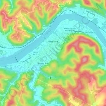
Name: Winfield topographic map, elevation, terrain.

Location: Winfield, Putnam County, West Virginia, United States (38.51452 -81.90950 38.54238 -81.85421)

Average elevation: 223 m

Minimum elevation: 165 m

Maximum elevation: 307 m

Other topographic maps

Click on a map to view its topography, its elevation and its terrain.

Liberty

United States > West Virginia > Putnam County

Average elevation: 281 m

Gear up for your next adventure:

🧶550 Survival Paracord - Versatile utility cord for emergency repairs and rigging
🧤Thermal Hiking Gloves - Grip-enhanced gloves for cold-weather altitude trekking
🛌Insulated Sleeping Pad - Critical thermal barrier between you and the cold ground
💡Compact LED Flashlight - Powerful and portable flashlight for outdoor use
🔭Compact Monocular - One-handed bird watching and trail spotting

As an Amazon Associate, this site earns from qualifying purchases at no extra cost to you.