
Make a donation
Gear up for your next adventure:
As an Amazon Associate, this site earns from qualifying purchases at no extra cost to you.
Parung Panjang topographic map
Click on the map to display elevation.
Make a donation
Gear up for your next adventure:
As an Amazon Associate, this site earns from qualifying purchases at no extra cost to you.
About this map
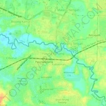
Name: Parung Panjang topographic map, elevation, terrain.
Location: Parung Panjang, Bogor, West Java, Java, 16360, Indonesia (-6.36220 106.55342 -6.32220 106.59342)
Average elevation: 50 m
Minimum elevation: 34 m
Maximum elevation: 68 m
Make a donation
Gear up for your next adventure:
As an Amazon Associate, this site earns from qualifying purchases at no extra cost to you.
Other topographic maps
Click on a map to view its topography, its elevation and its terrain.
Make a donation
Gear up for your next adventure:
As an Amazon Associate, this site earns from qualifying purchases at no extra cost to you.
Make a donation
Gear up for your next adventure:
As an Amazon Associate, this site earns from qualifying purchases at no extra cost to you.
Cisarua
The district is known for its mild climate, tea fields, and extensive views, being located at a rather high altitude. Near the district is a mountain pass known for its villas and hostels, as well as a well-known "heritage" hotel known as the "Puncak Pass", built in 1928.
Average elevation: 1,270 m
Make a donation
Gear up for your next adventure:
As an Amazon Associate, this site earns from qualifying purchases at no extra cost to you.
Make a donation
Gear up for your next adventure:
As an Amazon Associate, this site earns from qualifying purchases at no extra cost to you.
Make a donation
Gear up for your next adventure:
As an Amazon Associate, this site earns from qualifying purchases at no extra cost to you.
Make a donation
Gear up for your next adventure:
As an Amazon Associate, this site earns from qualifying purchases at no extra cost to you.
Make a donation
Gear up for your next adventure:
As an Amazon Associate, this site earns from qualifying purchases at no extra cost to you.
Ciliwung
Mean rainfall reaches 3,125 mm, with a mean annual discharge of 16 m3/s as measured at Ciliwung Ratujaya observation station (231 km2). With such topographical, geological, and hydrological features, the Ciliwung River is often overflowing and inundating parts of Jakarta. The population along the Ciliwung…
Average elevation: 229 m
Make a donation
Gear up for your next adventure:
As an Amazon Associate, this site earns from qualifying purchases at no extra cost to you.
Ciliwung
Mean rainfall reaches 3,125 mm, with a mean annual discharge of 16 m3/s as measured at Ciliwung Ratujaya observation station (231 km2). With such topographical, geological, and hydrological features, the Ciliwung River is often overflowing and inundating parts of Jakarta. The population along the Ciliwung…
Average elevation: 328 m
Make a donation
Gear up for your next adventure:
As an Amazon Associate, this site earns from qualifying purchases at no extra cost to you.
Make a donation
Gear up for your next adventure:
As an Amazon Associate, this site earns from qualifying purchases at no extra cost to you.
Jonggol
Jonggol is a district (Indonesian: Kecamatan) in the Bogor Regency, West Java, Indonesia. It is located 50 km to the southeast of Jakarta and is part of the Greater Jakarta metropolitan area. The average elevation is 295 meters, maximum 732 m (1.890 m in Mounth Baud, Sukamakmur, Jonggol District), and minimum…
Average elevation: 237 m
Ciliwung
Mean rainfall reaches 3,125 mm, with a mean annual discharge of 16 m3/s as measured at Ciliwung Ratujaya observation station (231 km2). With such topographical, geological, and hydrological features, the Ciliwung River is often overflowing and inundating parts of Jakarta. The population along the Ciliwung…
Average elevation: 328 m
Make a donation
Gear up for your next adventure:
As an Amazon Associate, this site earns from qualifying purchases at no extra cost to you.