Geolocate

Mirrormont topographic map

Click on the map to display elevation.

About this map

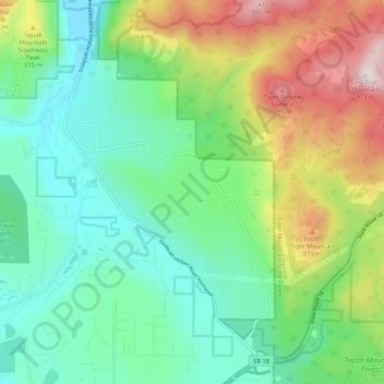
Name: Mirrormont topographic map, elevation, terrain.

Location: Mirrormont, Hobart, King County, Washington, United States (47.43549 -122.05472 47.49796 -121.95021)

Average elevation: 317 m

Minimum elevation: 45 m

Maximum elevation: 910 m

Gear up for your next adventure:

🌬️Windproof Camp Stove - Efficient cooking even on exposed mountain peaks
🧥Fleece Jacket - Warm and lightweight jacket for layering
🛌Insulated Sleeping Pad - Critical thermal barrier between you and the cold ground
🧭GPS Handheld Device - Reliable GPS navigation for outdoor adventures
🚑Survival Whistle - Signal for help across long distances in mountains

As an Amazon Associate, this site earns from qualifying purchases at no extra cost to you.