Geolocate

Potomac topographic map

Click on the map to display elevation.

About this map

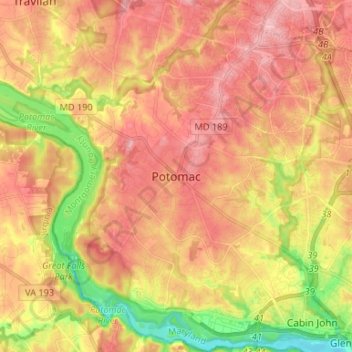
Name: Potomac topographic map, elevation, terrain.

Location: Potomac, Montgomery County, Maryland, 20854, United States (38.96668 -77.25590 39.06938 -77.14155)

Average elevation: 86 m

Minimum elevation: 8 m

Maximum elevation: 137 m

Other topographic maps

Click on a map to view its topography, its elevation and its terrain.

Carderock

United States > Maryland > Montgomery County > Potomac

Average elevation: 58 m

Gear up for your next adventure:

🥾Lightweight Hiking Shoes - Comfortable shoes for day hikes
🥾Hiking Boots - Sturdy boots providing ankle support and traction on rugged trails
🦌Outdoor Trail Camera - Monitor wildlife activity near your favorite spots
🧥Softshell Hiking Jacket - The perfect balance of wind protection and breathability
🧥Thermal Layer - Insulating layer for cold outdoor conditions

As an Amazon Associate, this site earns from qualifying purchases at no extra cost to you.