Geolocate

Antapur topographic map

Click on the map to display elevation.

About this map

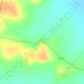
Name: Antapur topographic map, elevation, terrain.

Location: Antapur, Deglur, Nanded District, Maharashtra, India (18.57433 77.57836 18.61433 77.61836)

Average elevation: 374 m

Minimum elevation: 359 m

Maximum elevation: 395 m

Other topographic maps

Click on a map to view its topography, its elevation and its terrain.

Lendi

India > Maharashtra > Deglur

Average elevation: 396 m

Gear up for your next adventure:

🥾Waterproof Trail Shoes - Shoes designed to handle wet terrain
🧦Outdoor Socks - Durable socks designed for hiking and outdoor sports
Tent Footprint - Protect tent floor and increase durability
🧳Compression Sacks - Maximize space in your backpack by shrinking gear
🪑Insulated Seat Pad - Protect your seat from cold rocks and wet logs

As an Amazon Associate, this site earns from qualifying purchases at no extra cost to you.