
Make a donation
Gear up for your next adventure:
As an Amazon Associate, this site earns from qualifying purchases at no extra cost to you.
Hamra topographic map
Click on the map to display elevation.
Make a donation
Gear up for your next adventure:
As an Amazon Associate, this site earns from qualifying purchases at no extra cost to you.
About this map
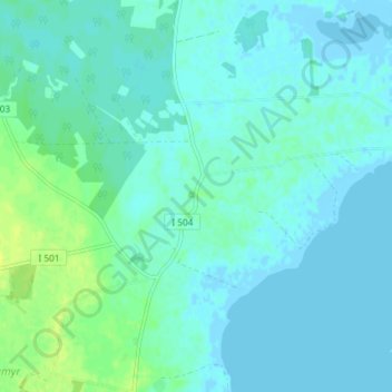
Name: Hamra topographic map, elevation, terrain.
Location: Hamra, Gotlands kommun, Gotlands län, Sverige (56.95589 18.29419 56.99589 18.33419)
Average elevation: 4 m
Minimum elevation: -5 m
Maximum elevation: 15 m
Make a donation
Gear up for your next adventure:
As an Amazon Associate, this site earns from qualifying purchases at no extra cost to you.
Other topographic maps
Click on a map to view its topography, its elevation and its terrain.
Gotlands kommun
Områdets berggrundsförhållanden formar kommunens horisontala och vertikala samt enskilda landformer. Detta medför att kommunen får en för riket unik topografi. Den genomgående låga landytan, som till största delen ligger under 30 meter över havet, är flack. Berggrundslagrens stupning gör att den…
Average elevation: 2 m