
Saint-Goazec topographic map
Interactive map
Click on the map to display elevation.
About this map
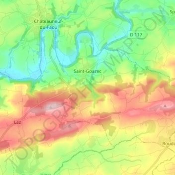
Name: Saint-Goazec topographic map, elevation, terrain.
Average elevation: 140 m
Minimum elevation: 33 m
Maximum elevation: 297 m
Other topographic maps
Click on a map to view its topography, its elevation and its terrain.
Kroaz an Teureg
Francia > Bretaña > Finisterre > Saint-Goazec > Kroaz an Teureg
Kroaz an Teureg, Saint-Goazec, Châteaulin, Finisterre, Bretaña, Francia metropolitana, 29520, Francia
Average elevation: 177 m