
Make a donation
Gear up for your next adventure:
As an Amazon Associate, this site earns from qualifying purchases at no extra cost to you.
La Rosière topographic map
Click on the map to display elevation.
Make a donation
Gear up for your next adventure:
As an Amazon Associate, this site earns from qualifying purchases at no extra cost to you.
La Rosière
La Rosière- Espace San Bernardo se situe dans la vallée de la Tarentaise au pied du col du Petit-Saint-Bernard, dans le département de la Savoie. Son altitude varie de 1 850 à 2 800 m, la station-village est située pour sa part à 1 850 m, son point culminant est le mont Valaisan, situé à 2 891 m.
Make a donation
Gear up for your next adventure:
As an Amazon Associate, this site earns from qualifying purchases at no extra cost to you.
About this map
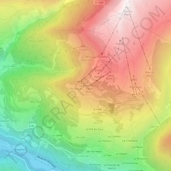
Name: La Rosière topographic map, elevation, terrain.
Average elevation: 1,598 m
Minimum elevation: 836 m
Maximum elevation: 2,331 m
Make a donation
Gear up for your next adventure:
As an Amazon Associate, this site earns from qualifying purchases at no extra cost to you.