Geolocate

Goimil topographic map

Click on the map to display elevation.

About this map

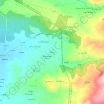
Name: Goimil topographic map, elevation, terrain.

Location: Goimil, Seteventos, Sarria, Lugo, Galicia, 27615, España (42.78671 -7.35671 42.82671 -7.31671)

Average elevation: 502 m

Minimum elevation: 411 m

Maximum elevation: 677 m

Other topographic maps

Click on a map to view its topography, its elevation and its terrain.

Chorente

España > Galicia > Sarria > Sarria

Average elevation: 626 m

Barbadelo

España > Galicia > Sarria > Sarria

Average elevation: 576 m

Ortoá

España > Galicia > Sarria > Sarria

Average elevation: 614 m

Louseiro

España > Galicia > Sarria > Sarria

Average elevation: 507 m

Vilamaior

España > Galicia > Sarria > Sarria

Average elevation: 623 m

Santo André de Paradela

España > Galicia > Sarria > Sarria

Average elevation: 578 m

Fontao

España > Galicia > Sarria > Sarria

Average elevation: 460 m

Gear up for your next adventure:

🧴Sunscreen SPF - Broad-spectrum sunscreen for outdoor activities
🥾Mountain Hiking Shoes - Shoes with superior grip for mountainous terrain
🔥Camping Stove - Portable stoves to cook outdoors with ease
🧥Ultralight Puffy Jacket - Maximum warmth that packs down to the size of an orange
🥾Light Trekking Boots - Supportive boots for multi-day treks

As an Amazon Associate, this site earns from qualifying purchases at no extra cost to you.